
Forgotten Waters


Mexican Hat Disposal Cell
Location: Halchita, UT. 4.4 million tons of residual radioactive materials. Less than one mile away from the San Juan River. Additional details on this page.
Challenges for Navajo Nation to Access Freshwater

Chantal is a jewelry vendor and Navajo (Diné). She lives in the Painted Desert near Cameron, AZ. Chantal does not have running water or electricity at home. The family cooks on a gas stove and over fire. They buy water from the trading post in Cameron or in Flagstaff.

Navajo boy demonstrating his skills. The family lives off grid on the Navajo Reservation near Cameron, AZ. They do not have access to fresh water or electricity. The boy's mom sells art on Hwy 64. They have a small farm with sheep and turkeys and ducks. The uncle hauls water from the trading post in Cameron.

"J" is an elder Navajo who lives in Cane Valley near Monument Valley at the border of Arizona and Utah. He does not have access to water or electricity. He must buy bottled water and gas from the grocery store in Goulding, UT, which is 26 miles away. Half of the route is on desert roads that are subject to flash floods and can be closed for several days after heavy rainfall.

"J" lives 200 feet away from an abandoned uranium mine. Mine tailings from several uranium mines in Cane Valley contaminated natural springs. The valley has plenty of groundwater. However, due to the contamination with heavy metals and other contaminants, it is not safe to consume the water.

This 3-generation family lives in a remote area on the Navajo reservation near Hard Rock, AZ. Due to nearby mining, it is no longer safe for them to drink water from natural springs. The non-profit organization Forgotten People hauls water every two weeks to fill their 255 gallon freshwater tank.

Bradley is a Navajo (Diné) who lives near Church Rock, NM. He has been advocating for decades to get uranium mine tailings near his property moved away. He is an active member of the Red Water Pond Road Community Association (RWPRCA), a grassroots organization of Diné families who have experienced and lived with the impacts of uranium mining and milling in the Church Rock mining area since the 1960s.

Raymond (Diné) fills a 255 gallon water tank at the trading post in Cameron AZ, for livestock, agriculture, toilet flushing and dish cleaning. He has running water at home. However, his extended family lives nearby and does not have water, nor electricity. The water line is close, but the house is not hooked up. Due to uranium mining the family no longer has access to safe drinking water from ancient wells. Hey pays $4 to fill up the 255 gallon tank.
Sacred Land

More than 60 uranium mines were operated between 1944 and 1962 near Monument Valley, a sacred site of the Navajo Nation. Monument Valley, with its world famous sandstone buttes, was a popular backdrop for Western movies.

The Monument Valley Navajo Tribal Park is a touristic area that attracts 350,000 visitors each year. Very little information about uranium mining and the health issues caused by it is displayed at the visitor center.

"J" visiting the abandoned uranium mine in Cane Valley that his father owned.

Anasazi cliff dwellings from the 12th century. A sacred place no one is allowed to enter.

Painted pottery was used for ceremonies. Shards show where Navajo used to set winter camp and shelter from cold winds.

The Navajo belief that pottery shards are sacred and should never be touched.

Totem Pole (right) and Yei Bi Chei (left), rock spires and holy, god-like figures for the Navajo in Monument Valley. The rock formation is seen as spiritual dancers emerging from a Hogan. Yei Bi Chei (Yébîchai ceremony) is a Night Chant and known as healing dance at a sacred nine-night ceremony in which masked dancers personify the gods

Petroglyphs (rock carvings) by Native Americans (Anasazi, Navajo, and Pueblo) at a sacred site near Tuba City, AZ tell the story of ancient indigenous tribes and how they hunted deer, grew corn and lived in harmony with Mother Earth.

Many places in or near Monument Valley are sacred to the Navajo people. It is where they perform traditional, spiritual ceremonies, rituals and chants.
Native Farming & Agriculture

Contaminated well used to water a corn field and water melons. The groundwater can not be used as drinking water. However, since hauling clean drinking water for agriculture and livestock is costly and time-consuming, local residents have no choice but to use existing and unsafe water.


Corn field on the Hopi reservation near Moenkopi, AZ.

Abandoned well in Cane Valley Wash near the abandoned Harvey Blackwater No. 4 uranium mine. Groundwater in Cane Valley is contaminated with unhealthy levels of uranium, nitrate, and arsenic caused by chemical processing of uranium ore.


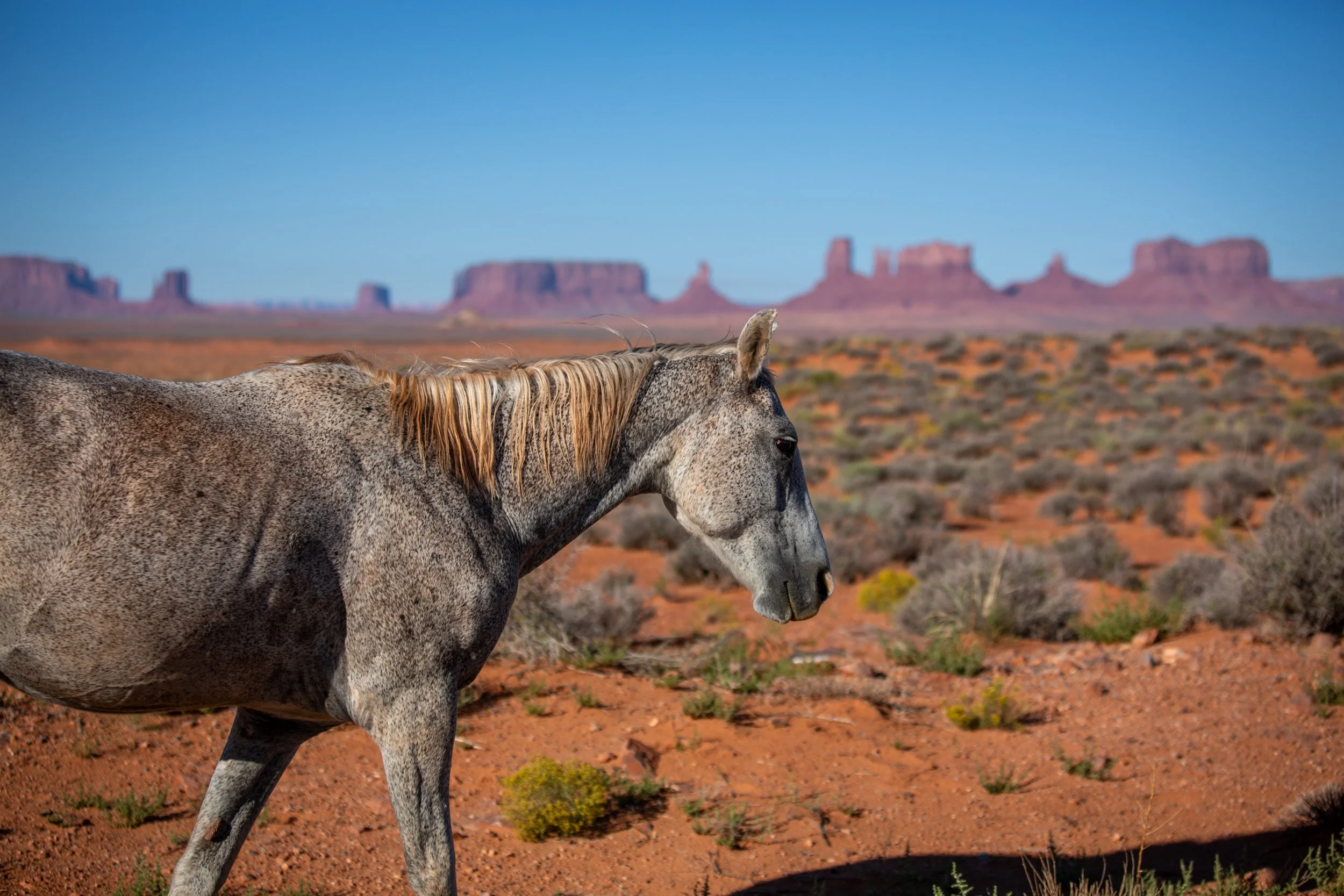
Unmonitored spring in Cane Valley that provides water year-round used for livestock. In hot summer months horses and wild donkeys stay close to a reliable water source.


Corn field on the Navajo reservation near Hard Rock, AZ

Raymond (Diné) fills a 255 gallon water tank at the trading post in Cameron AZ, for livestock, agriculture, toilet flushing and dish cleaning. He has running water at home. However, his extended family lives nearby and does not have water, nor electricity. The water line is close, but the house is not hooked up. Due to uranium mining the family no longer has access to wells. Hey pays $4 to fill up the 255 gallon tank.

The non-profit organization Forgotten People hauls water to elder Navajo who live in remote areas on the reservation.

Forgotten People provides clean drinking water, food deliveries, firewood, hygiene supplies, and basic goods to tribal members living in remote parts of the reservation. The Navajo Nation has been labeled a Food Desert and the people we serve often have to travel over a hundred miles to buy food. Some residents must travel 30-40 miles each way to haul safe water due to a lack of public water sources.

Corral partially constructed with wooden planks from underground uranium mines. After the mining companies left the area, the mines were left open and unsecured. Wind has blown radioactive mine tailings to nearby communities causing illness to people who never worked in the mines.
The Invisible Threat

Geiger counter showing elevated radioactivity near an abandoned uranium mine in Arizona.

Radioactive waste from the Monument No. 2 mine was disposed into the wash. Later it was covered with a thick layer of soil, leaving an ugly scar in the unique Monument Valley landscape. Run-off water digs deep ditches, unearths mine waste and washes radioactivity into Cane Valley Wash and into the San Juan River.

The beauty of the land is deceptive. Aerial photograph of the Charles Huskon No. 1 abandoned uranium mine near Cameron, AZ.


Quivira Mines. Near Church Rock, New Mexico, three former uranium mining sites hold a troubling legacy: one million cubic yards of radioactive waste. The Quivira Mines (aka Church Rock No.1 mines) stand as silent reminders of America's Cold War nuclear program and its impact on Navajo land. After years of partial cleanups and temporary fixes, the EPA has proposed a comprehensive solution in March 2024. Their recommended plan would transport all the waste to a new facility near Thoreau, New Mexico. The operation would be massive: 76,710 truckloads traveling 44 miles over 4.5 years, costing $182.5 million. While expensive and complex, this solution would permanently remove the contamination from Navajo land. Objectives are to prevent offsite migration of contaminants from mining activities that pose an unacceptable risk to human or ecologic health by soil, surface water, groundwater, or air. Since 2021, the EPA has held meetings with affected communities, conducted facility tours, and engaged with various Navajo chapters. This reflects a recognition that environmental decisions must include the voices of those most impacted. Communities face a significant choice: The proposed solution would eliminate the long-term health and environmental risks, but at the cost of years of truck traffic and disruption. It's a decision that weighs immediate impact against future benefit. The situation highlights broader issues of environmental justice, as this Indigenous community bears the burden from uranium mining. Despite the mines being closed for decades, the community continues to deal with the environmental and health impacts while facing challenges in getting their concerns fully addressed by government agencies.

San Juan River / Shiprock Disposal Cell, NM. The Shiprock disposal cell is located on Navajo Nation land in northwestern New Mexico, near the town of Shiprock. It contains radioactive waste and contaminated materials from a former uranium mill that operated from 1954 to 1968. The mill processed uranium ore to support the U.S. atomic weapons program during the Cold War. The mill was operated by Kerr-McGee Nuclear Industries. After the mill closed, approximately 1.5 million cubic yards of radioactive mill tailings and contaminated materials remained on site. In 1983-1986, the U.S. Department of Energy (DOE) carried out remediation under the Uranium Mill Tailings Radiation Control Act (UMTRCA). The waste was consolidated into an engineered disposal cell on top of the former mill site. Environmental concerns: 1. Groundwater contamination: The site has resulted in contamination of both shallow and deep groundwater aquifers with uranium, nitrate, sulfate, and other hazardous substances. This affects drinking water sources and agricultural use. 2. Surface water impacts: Seepage from the disposal cell affects the San Juan River and nearby arroyos. 3. Soil contamination: Despite remediation efforts, some areas around the former mill site retain elevated levels of radioactive materials. 4. Erosion risks: The disposal cell's location on an elevated terrace raises concerns about long-term stability.

San Juan River / Mexican Hat Disposal Cell. The Mexican Hat disposal cell originated from uranium mining operations in the 1950s-1960s. The site, located on Navajo Nation land, processed uranium ore for the U.S. atomic weapons program. Processing operations ended in 1965, leaving behind massive piles of radioactive mill tailings. Under the Uranium Mill Tailings Radiation Control Act of 1978, the Department of Energy conducted remediation from 1987 to 1995. The cleanup consolidated 2.8 million cubic yards of radioactively contaminated materials from both Mexican Hat and nearby Monument Valley sites into the current disposal cell. The site's history highlights environmental justice concerns, as uranium mining disproportionately impacted Navajo communities through occupational exposure and environmental contamination. The Mexican Hat disposal cell in Utah, containing approximately 4.4 million tons of uranium mill tailings, presents several environmental concerns: 1) Groundwater contamination from radionuclides and heavy metals seeping through the disposal cell. 2) The site sits above the Honaker Trail Formation aquifer. 3) Natural precipitation and flooding could potentially accelerate contaminant migration. 4) Erosion of cover materials could compromise containment. Monitoring data has shown site-related groundwater contamination. However, because of the isolation of the upper aquifer, the Department of Energy is not required to perform groundwater monitoring...

The Pinyon Plain Mine, formerly known as the Canyon Mine, is a controversial uranium mining site located in northern Arizona, approximately 6 miles southeast of the Grand Canyon's South Rim. The mine sits on U.S. Forest Service land within the Kaibab National Forest and is owned by Energy Fuels Resources, a Canadian company. Despite its proximity to the Grand Canyon National Park, the mine was initially permitted in 1986, before the 2012 moratorium on new uranium mining claims around the Grand Canyon. The mine has faced significant opposition from environmental groups and Native American tribes, particularly the Havasupai Tribe, whose reservation and sacred lands lie nearby. A primary concern is the potential contamination of groundwater and springs that are vital to both the ecosystem and tribal communities. The Havasupai people, whose name means "'the people of the blue and green sky and water", are particularly concerned about protecting their water sources in Havasu Canyon, which they rely on for drinking water and agricultural purposes. One of the most challenging aspects of the Pinyon Plain Mine has been its management of groundwater. The mine shaft has encountered significant amounts of groundwater during drilling, requiring constant pumping and water management. Energy Fuels has had to implement various measures to handle and treat this water, which contains elevated levels of uranium and arsenic. The company maintains that their operations are safe and comply with all regulatory requirements, while critics argue that the long-term risks to the region's water resources and environmental health outweigh any potential benefits from uranium extraction.

Warning sign at the Henry Sloan No. 1 mine, next to vendor stands along Hwy 89.

Warning sign at A & B No. 2, an abandoned uranium mine near Cameron, AZ.

Upgrader structure on AUM 457 near Cameron, Arizona. The remnants of a concrete structure called an “upgrader”, which was meant to increase the concentration of uranium in the ore from local mines.

Little Colorado River / Uranium Mining. Numerous abandoned uranium mines are located in close proximity to the Little Colorado River. There is clear scientific evidence that the Little Colorado River seasonally carries high loads or uranium – contamination that is carried directly into the Colorado River. While uranium occurs naturally in that area, we will look at human made situations upstream from Cameron, Arizona. This is an “upgrader” which was meant to increase the concentration of uranium in the ore from local mines. Elevated gamma radiation in soil was identified at the site during a site screen in 2011. Waste rock across the site from historical mining activities is the primary source of radiological and metals contamination. Excavation of mining related ore and waste rock from near-surface uranium deposits have dispersed metals and radionuclides into the local environment. In November 2024, the EPA published a proposal to remove remnants of the upgrader, concrete pads and foundations, unreclaimed waste piles, a former drainage pond and two abandoned mines. The removal of an estimated 14,711 cubic yards of contaminated soil will cost $4M. The cleanup includes excavating waste rock piles, residual waste rock, and contaminated soils; and consolidating and capping the waste in a regional repository located approximately one mile from the upgrader. According to the EPA this location would provide for increased distance from drainages and floodplains. The cap and exposed bedrock areas will require long-term maintenance.

Barricaded entrance of the John M. Yazzie No. 1 uranium mine in Cane Valley, AZ.

Carnotite, a radioactive, yellow mineral and ore of uranium, found on the surface of a cleaned up mine in Cane Valley, AZ. In the Navajo language uranium is called "leetso", which means yellow dirt.

The Homestake Mining Co. site, located 5.5 miles north of Milan, New Mexico, represents a significant environmental cleanup challenge stemming from uranium milling operations that began in 1958. The site encompasses a former uranium mill, two tailing disposal sites covering approximately 240 acres combined, and contaminated groundwater aquifers. The larger tailings impoundment stands 85-100 feet high and contains 21 million tons of mill tailings, while the smaller one is 20-25 feet high with 1.2 million tons of tailings. The facility operated until 1990, and the mill was decommissioned between 1992 and 1995. In 1981, Homestake Mining Company took full ownership before merging with Barrick Gold Corporation in 2001. The primary environmental concern at the site is groundwater contamination, first discovered in 1960, which led to its designation as a Superfund site in 1983. Seepage from the tailings impoundments has contaminated multiple aquifers with uranium, selenium, radium-226, radium-228, thorium-230, chromium, molybdenum, vanadium, sulfate, chloride, nitrate, and total dissolved solids. The contamination has necessitated connecting nearby residents to municipal water supplies for safety. While groundwater migration is currently considered under control, cleanup efforts continue through a complex system of groundwater collection, injection, and treatment facilities. Recent investigations in 2023 are examining whether "back diffusion" - a process where contaminants bound in clay layers slowly release back into groundwater - might extend the cleanup timeline for decades or centuries. Additionally, EPA's 2023 reassessment of background groundwater quality has led to significantly lower acceptable background levels for contaminants like uranium and selenium, which will influence future cleanup goals.

Tuba City Disposal Cell, AZ. The disposal cell is located on Navajo Nation land, near the Hopi reservation, approximately five miles east of Tuba City. Uranium and vanadium ore processing occurred there between 1956 and 1966. The mill produced around 800,000 tons of uranium mill tailings. The disposal cell was completed in 1990. The DOE moved approximately 1.4 million cubic yards of contaminated materials into a engineered disposal cell covering about 50 acres.

Tuba City Disposal Cell, AZ (cont.). There have been ongoing concerns about contamination of the underlying aquifer, which is a source of drinking water for local communities. Monitoring has shown elevated levels of uranium, nitrate, and sulfate in the groundwater. A few alarming numbers (estimates) from the 2023 Groundwater Remedy Performance Update: During milling a maximum of 100 tons of uranium was infiltrated into the ground. The current uranium plume in the aquifer contains 550 million gallons of contaminated water and increases by an average of 40 million gallons per year. The average uranium concentration is 190 μg/L, 36% up from 140 μg/L in 2008, about six times the EPA's limit for drinking water (30 μg/L). The site's location on Navajo Nation land has raised environmental justice concerns about the disproportionate impact of uranium mining and processing on Indigenous communities.

Monitored well at the location of the former uranium processing site in Cane Valley, AZ. Contaminated mill waste was removed between 1992 and 1994 and transported to the Mexican Hat Disposal Site, approximately 15 miles north of the site.

Remaining rock tower at the Monument No. 2 mine.

Mine tailings at the Monument No. 2 mine.

Abandoned miner's home near a uranium mine in Cane Valley, AZ.

Mine tailings at the Monument No. 2 mine.
Protests

"Protect The Sacred" sign in Kayenta, AZ. Also, the name of a nonprofit organization that educates and empowers the next generation of Native leaders to strengthen Indigenous sovereignty.

Road sign outside of Cameron, AZ. Forty years after the last uranium mine was closed, the Navajo Nation continues to grapple with environmental issues, cancer cases, birth defects and sickness related to contaminated groundwater, soil and polluted air.

Mural at an abandoned gas station by local artist Daniel Josley near Kayenta, AZ.

Red Water Pond Road Community Association (RWPRCA) is a grassroots organization of Diné families who have experienced and lived with the impacts of uranium mining and milling in the Church Rock mining area since the 1960s. Their mission is to restore the land and water contaminated by uranium mining, improve the health of community members, and protect and preserve the natural and cultural environment in which they live.

Bradley is Navajo (Diné) near Church Rock, NM and has been fighting for decades to get uranium mine tailings near his property moved away. He is an active member of the Red Water Pond Road Community Association (RWPRCA), a grassroots organization of Diné families who have experienced and lived with the impacts of uranium mining and milling in the Church Rock mining area since the 1960s.
All photographs copyright (c) 2021 - 2025 by Stefan Frutiger.